Get ready for a stretch of steamy and stormy weather across the West Chicago area, with multiple alerts in effect this week.
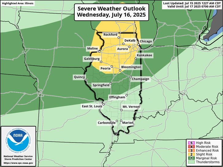
The National Weather Service is warning residents to prepare for strong to severe storms on Wednesday, following a sweltering afternoon that could bring heat index values near 100 degrees. High humidity and soaring temperatures are expected to build through midweek, setting the stage for potentially dangerous weather.
Before the storms roll in, an Air Quality Alert remains in effect through Tuesday evening for the Chicago metro area. The alert was issued due to elevated ozone levels and lingering effects of smoke from Canadian wildfires, which could make breathing difficult for sensitive groups, including children, the elderly, and those with respiratory conditions.
Storm chances begin increasing Wednesday afternoon, with the possibility of strong to severe storms developing into the evening. These storms could bring damaging winds and flash flooding, though meteorologists say there’s still uncertainty regarding exactly where the heaviest storms will hit. Officials encourage residents to check for frequent forecast updates.
Here’s what to expect day-by-day:
Tuesday Night: Partly cloudy skies with a low around 73. Winds from the south at 5 mph becoming calm overnight.
Wednesday: Mostly sunny and hot, with a high near 91. Heat index values could climb to 100 degrees. A 30% chance of showers and storms develops after 1 p.m. Winds from the southwest at 5 to 15 mph, gusting up to 20 mph.
Wednesday Night: Showers and thunderstorms likely, especially late. Mostly cloudy with a low around 69. Rain chance: 60%. Winds remain out of the southwest at 5 to 10 mph, with gusts up to 15 mph.
Thursday: A 50% chance of storms continues. Mostly cloudy and cooler, with a high near 78. Winds shifting from the west to northeast at 5 to 10 mph, gusts up to 20 mph.
Thursday Night: Mostly cloudy with a low around 61.
Friday: Looking drier, with mostly sunny skies and a high near 80.
Friday Night: Partly cloudy, low around 65.
Storms are expected to return over the weekend, with the Weather Service noting “periodic bouts” of rain and storms from Saturday through Monday. These systems could once again bring heavy downpours and localized flooding.
Residents are advised to stay weather-aware, limit outdoor activity during poor air quality hours, and have a plan in case of rapidly changing storm conditions.
Alerta Meteorológica para West Chicago: Altas Temperaturas, Tormentas Severas y Mala Calidad del Aire en el Pronóstico
Prepárese para una semana calurosa e inestable en el área de West Chicago, con varias alertas meteorológicas en efecto.
El Servicio Meteorológico Nacional advierte sobre la posibilidad de tormentas fuertes a severas el miércoles, luego de una tarde muy calurosa con valores de índice de calor cercanos a los 100 grados Fahrenheit. Se espera que el calor y la humedad aumenten hasta mediados de semana, creando las condiciones ideales para tormentas potencialmente peligrosas.
Antes de que lleguen las tormentas, una Alerta de Calidad del Aire permanece vigente hasta la noche del martes para el área metropolitana de Chicago. La advertencia se emitió debido a niveles elevados de ozono y los efectos persistentes del humo de incendios forestales en Canadá, lo cual podría dificultar la respiración para grupos sensibles como niños, personas mayores y aquellos con afecciones respiratorias.
Las probabilidades de tormentas comienzan a aumentar el miércoles por la tarde, con posibilidad de que algunas se vuelvan fuertes o severas hacia la noche. Estas tormentas podrían traer vientos dañinos e inundaciones repentinas, aunque los meteorólogos advierten que aún hay incertidumbre sobre las áreas más afectadas. Se recomienda a los residentes mantenerse atentos a las actualizaciones del pronóstico.
Pronóstico detallado por día:
Martes por la noche: Cielo parcialmente nublado, con mínima alrededor de 73°F. Viento del sur de aproximadamente 5 mph, disminuyendo por la noche.
Miércoles: Mayormente soleado y muy caluroso, con máxima cerca de 91°F. El índice de calor podría alcanzar los 100°F. Hay un 30% de probabilidad de lluvias y tormentas después de la 1 p.m. Vientos del suroeste de 5 a 15 mph, con ráfagas de hasta 20 mph.
Miércoles por la noche: Lluvias y tormentas probables, especialmente en horas de la noche. Mayormente nublado, con mínima cerca de 69°F. Probabilidad de precipitación: 60%. Vientos del suroeste de 5 a 10 mph, con ráfagas de hasta 15 mph.
Jueves: Probabilidad del 50% de lluvias y tormentas. Mayormente nublado, con máxima cerca de 78°F. Viento del oeste cambiando al noreste entre 5 y 10 mph, con ráfagas de hasta 20 mph.
Jueves por la noche: Mayormente nublado, con mínima alrededor de 61°F.
Viernes: Mayormente soleado, con máxima cerca de 80°F.
Viernes por la noche: Parcialmente nublado, con mínima alrededor de 65°F.
Se espera que las tormentas regresen durante el fin de semana, y el Servicio Meteorológico señala “episodios periódicos” de lluvias y tormentas desde el sábado hasta el lunes. Estos sistemas podrían traer nuevamente fuertes lluvias e inundaciones localizadas.
Se recomienda a los residentes estar atentos a las condiciones del clima, evitar actividades al aire libre durante los periodos de mala calidad del aire, y tener un plan listo en caso de cambios rápidos en las condiciones meteorológicas.